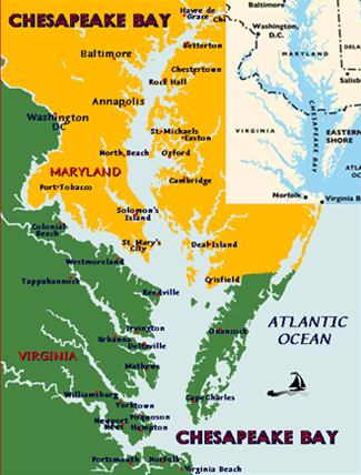
Estuary is the term for a waterway where fresh and sea water mingle. The Chesapeake Bay is the largest estuary in the continental United States. From its mouth in southern Virginia the bay spans a 195 mile distance, travelling between the Virginia and Maryland mainlands and the Delmarva Peninsula which forms its eastern bank. It contains more than 7 miles of shoreline, spans 30 miles at at its widest point and averages less than 30 feet in depth.
Watershed is the area around a body of water which drains into the waterway. The National Park Service tells us that there are "over 120 parks, refuges, museums, historic communities and water trails in the Chesapeake Bay watershed," which covers a 64,000 mile area of land and tributaries which flow into the Bay. Portions of Delaware, West Virginia, Washington, D.C., Pennsylvania and New York are contained in the watershed.
Wetlands is land at the water's edge which provides protection to the land from wind, waves and flooding and protects the water by catching and containing pollution. The wetlands house and feed animal and plant species native to a marsh environment as well as the offspring of species which spawn along the edges of the Bay.
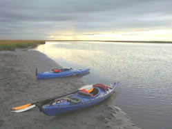
 The Bay's southernmost region, on the Virginia coast, provides abundant opportunities for getting to know the estuary. Visitors travel the Chesapeake to learn about its native organic life and to fish, kayak, canoe. It's a great vacation spot too! There are many miles of hiking and biking trails along the shore, and If you aren't an exercise lover, there are also plenty of comfortable roads for vehicles.
Summer is the best time to vacation in Virginia's Chesapeake Bay. Bay temperatures are cold (39.5° F) during winter months, but in July the air temperature averages 77° F and water temperatures in late July are a warm 80-86° F. The southern leg of the Chesapeake, at the estuary's mouth where it mixes with the Atlantic Ocean, is naturally the saltiest portion of the Bay. Salinity runs about 20 parts per mille at the point where the James River enters the Bay, and drops to 15 parts where the Bay intersects with the York River. Where the Bay meets the Atlantic, the water is 25 grams per mille. In other words, dive in, the water's fine!
Although the southern Chesapeake's water may be fine for swimming, the balance between life forms in the estuary is as important as the balance between salt and fresh water, and it has been too greatly disturbed. A water body's health can quickly degenerate when there are too many nutrients in the water, which puts too strong a demand on the available oxygen supply and muddies the water. Levels of phosphorous and nitrogen are extremely high in the Chesapeake due to runoff from farms and sewage treatment plants, the amount of dissolved oxygen in the water is low, and fishing advisories due to toxicity are in place in many locations throughout the Bay's watershed.
 Initiatives to save this important waterway and wildlife habitat are also on the rise. It was discovered that the once vast oyster population in the lower Chesapeake Bay, filtered all of the Bay's water every three days and kept the waters clear and healthy. Now, sanctuary reefs like those created by oysters, but no longer standing, are being built and "oyster gardens" are being grown throughout the coastal regions by citizens, students and government agencies in Virginia, to help populate them.
In a study published August 2001 in Science, the authors make the case that cultures which lived centuries ago overfished key reef ecosystems and set in motion the foundation for today's water pollution. But co-author Roger Bradbury of the Australian National University in Canberra offers advises, "We need to change the way we think about our coastal seas-not pristine, but damaged, and equally not hopeless, but salvageable."
Visitors to the southern Chesapeake Bay are within spitting distance of Historic Williamsburg, Virginia and the Chincoteague Island, a wildlife reserve famous for its herds of wild ponies. Sago pondweed and redhead grass make their home in the Bay. You will also find native oysters, clams, blue crabs and in the skies, great blue herons and bald eagles. And these are only a few of the 2700 species of plants and animals living in the Bay. There are also 267 types of fish including white perch and American eel.
Interestingly enough, the Bay's inhabitants possess the natural equipment to preserve the health of their native environment. Writing for the Bay Journal, Tawna Mertz explains how important oysters are to the Bay's ecosystem. "Oysters are filter-feeders that consume excess algae and other nutrients to help keep Bay waters clear . . . their reefs, which once rose high from the Bay bottom, provided important shelter for young fish, food for older fish and solid structures for numerous other filter-feeders, such as clams and mussels."
Dramatic changes in the ration of fresh to sea water create equally dramatic changes among the Bay's living population. While people need a certain balance of chemicals in our bodies to be healthy, the bodily health of the estuary's plants and animals depends on the conditions in their watery habitat.
For example, oysters cannot survive in water which fails to contain any salt at all, but they survive poorly in overly saline conditions, because the species of bacteria which attack them thrive in highly salted water. In the drought year of 2002, less fresh water drained into the Bay from its watershed, so there was more salt in the Bay because the sea water ran into the Bay to top up the water supply. Consequently, the Bay's oyster population declined heavily that year.
When you visit the Chesapeake Bay in Virginia, take advantage of the opportunity to learn about the is the exciting leading-edge efforts being undertaken by a collaboration of local and federal governments, businesses, non-profit organizations and individual volunteers, to restore the health of the Bay, and its watershed area, for recreation and consumption.
The Alliance for the Chesapeake Bay is a private-public partnership helping to create environments lush with plants and flowers on Richmond rooftops. Rooftop vegetation captures and retains precepitation so areas flood less easily and so there are less car oils, contaminated soil and garbage being swept along by rainfall into the Bay. Green Roofs insulate buildings and protect roofing material from solar exposure, so investing in their creation makes economic as well as environmental sense.
The Chesapeake Bay Foundation's sponsors the "Get Dedicated" campaign to clean the Bay and trains Chesapeake Stewards to teach local residents what how to join in the effort to save the Bay.

Historic home on 140 acre farm. Beautiful, expansive views of Occohannock Creek and Chesapeake Bay. Pool, dock, fishing, crabbing, beach, fireplaces, library, porch, bicycles, antiques. Golf, tennis, shops, restaurants and galleries are nearby.
Find other inns at Virginia Bed & Breakfasts
A Chesapeake Bay Epicurean Delight on the Eastern Shore of Virginia in Onancock Virginia. Visit Onancock and Armando's....... A delightful array of seafood, steaks, Italian foods & more for boaters and land-lovers alike.
Denny and Glenna Crockett continued Hilda Crockett's tradiiton of providing a friendly atmosphere and great meals to all those who come to the Chesapeake House during their visit to Tangier Island April 15 to October 31 of each year.
| A Virginia State Parks site | http://www.state.va.us/dcr/parks/1stland.htm |
| Eastern Shore Tourism | http://www.state.va.us/dcr/parks/1stland.htm |
| Tourism Information | http://www.chesapeakebaysampler.com |
| Chesapeake Bay water tours | http://www.geocities.com/discoverva/chesapean.html |
| Maryland Natural Resource Magazine | http://www.dnr.state.md.us/naturalresource/ summer2004/chesapeake.html |
| Virginia Marine Science Museum | http://www.vmsm.com/index.shtml |
| Chesapeake Bay Program | http://www.chesapeakebay.net |
| Captain John Smith 400 Project | http://johnsmith400.org/index.php |
| Chesapeake Bay Foundation | http://www.cbf.org |
| Bay Journal | http://www.bayjournal.com/article.cfm?article=1589 |
| Regional and State Assets | http://www.yorkcounty.gov/econdev/regassets.htm |
| Sea Grant Ocean Sciences Resource Center | http://www.vims.edu/bridge/index_chesbaytip.html |
| Bay Weekly's Summer Guide 2002 | http://www.bayweekly.com/year02/summerguide/summer61-70.html |
| Green Roofs Project | http://www.acb-online.org/project.cfm?vid=240 |
| Bay Gateways | http://www.baygateways.com |
| Northern Neck | http://www.northernneck.com/ |
| Chincoteague National Wildlife Refuge | http://www.fws.gov/refuges/profiles/index.cfm?id=51570 |
| Salinity / Temperature / Dissolved Oxygen Data | http://www.chesapeakebay.net/status/wquality/interpolator/do/gallery.htm |
| Department of Environment Quality | http://www.vanaturally.com/guide/bayandcoast.html |
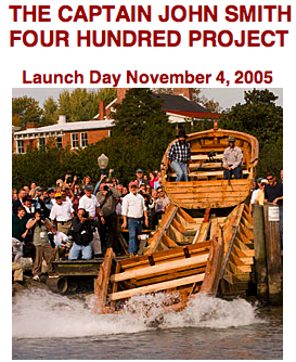
"On June 2, 1608, only one year after the founding of Jamestown, Captain John Smith and 14 English colonists set out on a journey to explore and map the Chesapeake Bay. Covering more than 1,700 miles in just over three months, Smith and his men saw a Chesapeake that is scarcely imaginable today . . . "
If you've enjoyed learning a little about the Bay on this website, you'll have plenty of fun exploring the magic of the New World with the John Smith 400 Project. Begin your Chesapeake Bay journey today!